Karagiye depression: below sea level, above human body (1/3)

Intro: sea or lake?

Despite the name, the Caspian Sea actually is a big lake, as it is completely landlocked, without a connection to the oceans. Beside its huge size (with 371000 square km is the largest lake in the world by far) owns another peculiarity: it lies 28 meters below the mean sea level. Even if it is situated in an arid climate, the salinity is much lower than in the oceans (about one third), mainly due to the fresh water influx (Volga river). Around the lake, especially in the northern sector, there is an extensive sunken plain area named “the Caspian Lowland”, a sparsely populated flatland covered with xerophyte shrubs and grass.

“Skal’naya tropa”, the rocky coast of Aktau

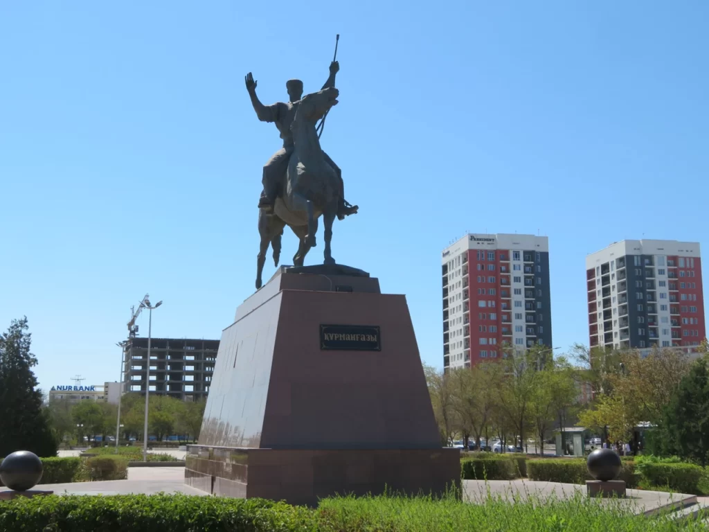
Centered around the oil industry, the city of Aktau lies on the eastern shore of the “sea” and is the capital of Mangystau region in south-western Kazakhstan. In the summer the climate resembles the mediterranean one (warm to hot with little rainfall), the coast being frequented by locals in the holidays. International tourism it just started to develop, hence is a great option for those travelers who want to have a unique and less crowdy beach experience. Above the specific “soviet background” (wide streets, rectangular structures, heroic memorials) the present day Aktau presents a peaceful atmosphere, trying to connect to the western standards.

Choosing the target

Compared with my usual work ethic regarding the extreme climate research, this travel wasn’t planned well ahead, instead was closer to a “last minute” decision. With less free time available I chose a somewhat “easier target”, both physically and financially.

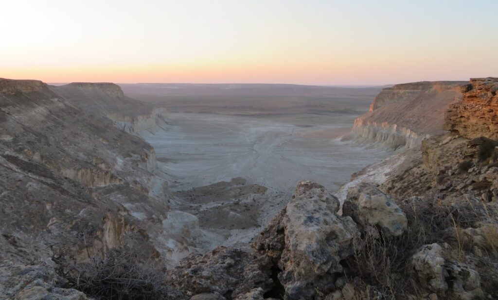
Having a particular bonding with the lowest dry lands by a lifetime, the Karagiye Depression in south-western Kazakhstan popped up as the best choice in this more limited context. The bottom of the semi-desertic depression lies at 132 meters below the sea level, representing the lowest point of Kazakhstan (also the former Soviet Union) and position oneself fifth in the world after the Dead Sea (Israel-Jordan), Lake Assal (Djibouti), Turfan basin (China/ Xinjiang) and Qattara depression (Egypt).

The Karagiye Depression (red arrow) situated inside the Caspian Lowland (dark green, upper part of the image)

From the viewpoint of the hottest places of the Planet in the absolute sense can’t be considered a “top-notch” location, but taken into account its relatively high latitude (43 N) in the summertime has a decent delivery potential. The proximity to the coast (20-40 km) doesn’t really affect the daytime heating as the Caspian has a quite continental ambience and the sea-breeze is often completely annihilated by the dry easterly winds blowing from the inland deserts.

Soviet military topo map with Karagiye (center) and Aktau (formerly Shevchenko) in the north-west

Moderated by the sea, Aktau itself has an average summer maximum of around 31-32 degrees, with the absolute record of 44 degrees Celsius measured in the month of August (according to Wikipedia). I have no access to the weather statistics of the more inland locations in Mangystau and I’m not even sure there are real weather stations outside the regional capital in the closer surroundings.

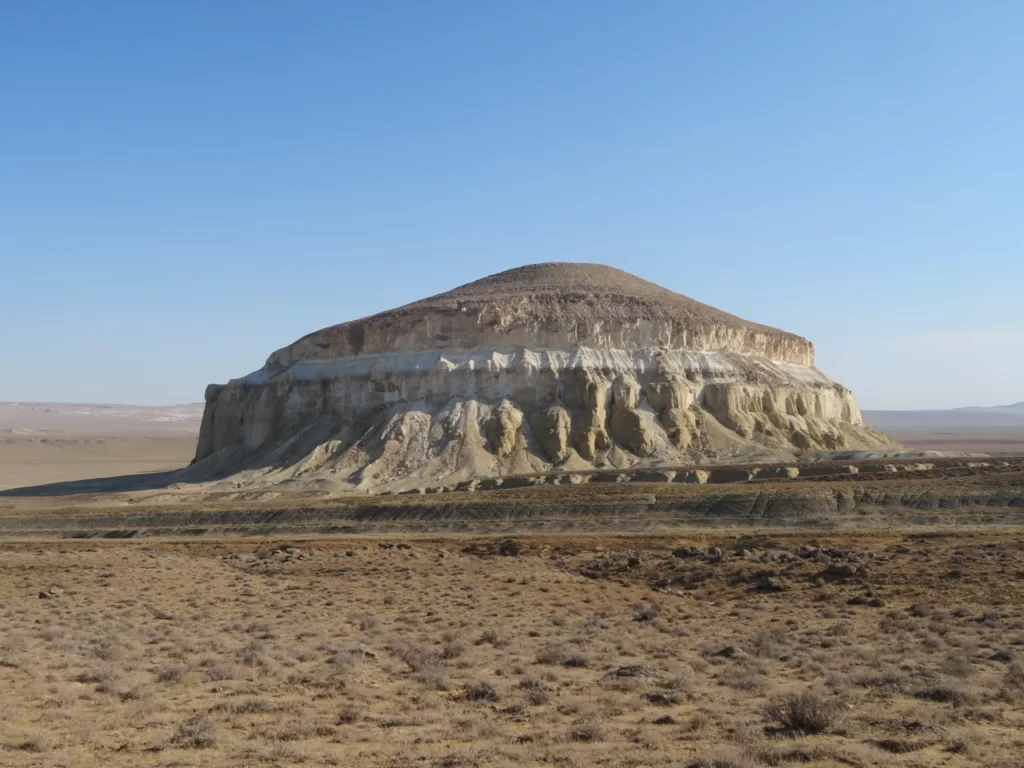
The place has a peculiar topographical setting, being a “depression inside a depression”, as the nearby Caspian Sea itself is already situated below the level of the world ocean, while Karagiye lies another hundred meters lower than the big lake.

Satellite image with the location of the measuring equipment (red dot) in the north-eastern part of the basin

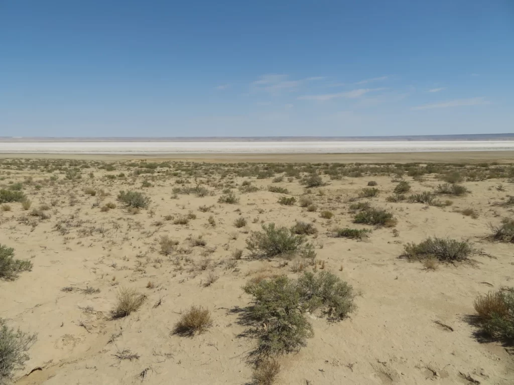
Regarding the exact location of the research I’d chosen a spot which is the farthest possible from the coast (37-38 km), while at the same time being at the lowest elevation (-132 m). Also, I’ll try to place the tripod on sandy surface, as it can slightly enhance the daytime heating compared with the more compact clay or the highly reflective salt crust (white patch in the above image).

The low-point can be reached the easiest way from the Aktau-Zhanaözen road (new turkish asphalt), from where it is about 10 km to the south, south-west, lying at the foot of the steep eastern rim of the basin.

Brief summary of the research

My plane landed in Aktau on 11th August in the early morning, just before sunrise. The optimistic forecast rushed me to reach the bottom of Karagiye and place the measuring equipment as soon as possible. Everything went fine, the locals were helpful and even if I slept close to nothing during the flight journey, the quick preparation was efficient and around 9 AM a car left me on the Zhanaözen road right at the viewpoint to the depression, from where I started the hike towards the bottom.

Descending into the Karagiye depression

Before 10 AM it was already hot, the sky completely clear and only weak wind. After meandering my way through the fragmented escarpment, I reached the flatter part and continued the walk, crossing the sometimes harder clayey, other times more squashy salty terrain with generally sparse vegetation cover. Finding a proper sandy spot on the bottom I mounted the data logger on the tripod around 12:30 PM. The exact coordinates are: 43.490923 N, 51.838903 E, the elevation -130 m. The height of the sensor from the ground is around 170 cm. At 12:42 PM the weather station started its operation. First reading: 36.6 degrees Celsius.

The weather station on the bottom of the basin

I waited near the equipment until 5 PM, to monitor the temperature rise during the hottest part of the day. The maximum reached 40.1 degrees Celsius at 4:48 PM, while I randomly measured 64.3 degrees soil temperature around 1:30 PM during the highest sun angle. Before leaving I secured the tripod attaching a sack filled with soil fragments to can handle also the windier conditions.

I’ve spent the night in a mosquito tent less than 1 km from the weather station, next to a consolidated sandy pile. Despite the clear skies, partly because of the wind, the evening was warm and the night’s minimum dropped only to 28.9 degrees Celsius. I left the research area at dawn and returned to collect the equipment four days later, on 16th August in the afternoon. During this intermediate period, beside Aktau, I travelled to other locations of the Mangyshlak peninsula (Shetpe town, Caspian coast), where encountered similar dry and hot conditions with little to no clouds.

The maximum (40.1 degrees Celsius) was reached at 4:48 PM

On 16th August I crossed the Karagiye depression, starting the hike from the other side (Kuryk road), reaching the study area after traversing the salt pan situated at the very bottom. The weather was mostly sunny but somewhat less hot than in the first day, though still far from comfortable. I found the instrument in its place and functional with all data recorded correctly. The absolute maximum surpassed by half a degree (40.6 degrees Celsius) the first days peak both on 12th and 13th, while the weakest maximum happened on 15th (36.0 degrees). The lowest value was registered on 16th in the morning, when the temperature dropped to 19.3 C, by far the coldest night.

The salt pan at -132 m

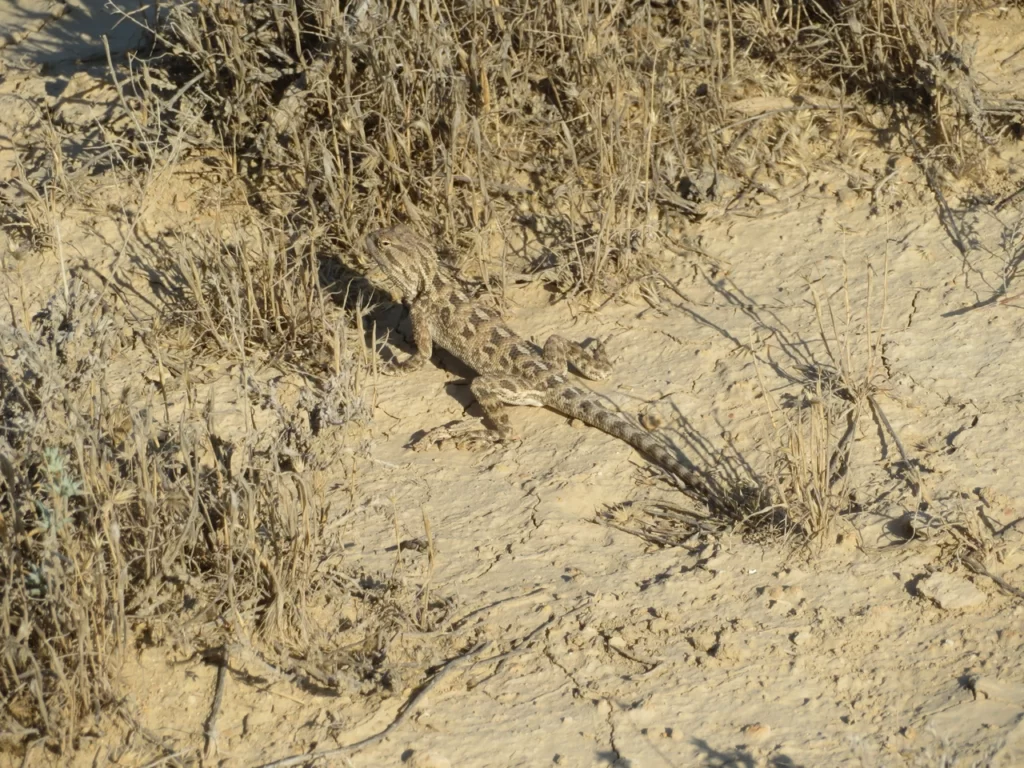
During my staying in the depression I encountered a few gazelles, camels and horses, respectively birds in the more vegetated parts. Small lizards, a few bugs and a species of spider (night time) was also present. There were no humans in the entire area between the two asphalt roads (Zhanaözen and Kuryk).

The instruments used on the field

-One LogTag UTRED30-16 data logger with the measuring range between -40 and +99 degrees Celsius, an accuracy of 0.5 degrees Celsius and a resolution of 0.1 degrees Celsius.

-One Greisinger GMH 2710-T digital precision thermometer with the measuring range between -199.9, +200 degrees Celsius, an accuracy of +-0.1 degrees Celsius and a resolution of 0.1 degrees Celsius.

-One photo camera tripod serving as the support for the instruments.

-One helical solar radiation shield from Barani Design Technologies: https://www.baranidesign.com/

Soil temperature around noon

To be continued…

Karagiye depression: below sea level, above human body (2/3)

Journey photo album

My plane landed in Aktau shortly before sunrise and I had the luck to catch a glimpse of the Karagiye salt flat (whitish patch below the horizon) while approaching the Caspian coast

The first impression of Kazakhstan was very positive and not only because of the sunny weather, but also the openness and helping attitude of the locals

Thus, with the assistance of the airport taxi driver who understood and was ready to help me with the basic preparations in a fast and straightforward manner, I managed to reach the starting point of the hike at the “Karagiye viewpoint” situated about 55 km distance from the city on the Zhanaözen road around 9 AM

Packed with 9 liters of water and sufficient food, at 9:30 AM I started the descent towards the bottom of the depression
The first part of the route is given by the steep ledge of the plateau, which drops in more steps, separated by flatter terraces, a prehistoric and dramatic landscape with the aspect of a labyrinth. The dominant rock type is clay and marl, generally quite friable

Around 10 AM it was already hot and the absence of the wind inside the gullies made the solar radiation even more pronounced. I am content, this is what I came for

Some gazelles wandering in the wilderness
Reaching the flatter bottom part (already below -100 m elevation) I continued the hike, turning to the south-east and generally following the line of the escarpment. In some parts there was some vegetation…
…while in other parts it was completely missing, the landscape resembling the surface of the Moon
small step…Big step 🙂
Even here you can see sometimes the signs of life, this bird certainly came from the neighboring greener areas, where he/she resides
Here and there the monotony of the flatland is interrupted by a few consolidated sandy piles
After 12 PM I reached a spot which I consider proper to place the tripod with the attached logger. This is a smaller sandy “island” situated at the edge of the extensive clayey bottom (the GPS shows around -130 m), which could slightly enhance the daytime heating as compared with the more compact or reflective surfaces
At 12:40 I started the logger. For a short period there was some trouble as the sensor’s contact seemed to fluctuate, but luckily, after a few attempts I managed to solve the issue
The Barani helical radiation shield warrants for the efficient protection against the sun, providing both shade and sufficient ventilation to measure the actual air temperature

Soil temperature around 1:30 PM, the highest solar angle
Unlike the dusty and squashy one, this surface is particularly hard and rough
The Zobject likes it too
As I had both enough time and energy, without the luggage, I made a small bypass to the last visible sandy pile situated more inside the depression (around 1.5 km from the camp), which has on the top a small lookout tower
I was a little surprised that I couldn’t observe from here the white expanse of the salt pan, probably still too far with such a small elevation advantage
Some greenery at the foot of the ledge
The only shade is my own
Back to the camp: the temperature is rising

As I lost my “legionary hat” before embarking in the minibus in Aktau, I’ve used a white T-shirt for protection against the insolation. I am sitting in a small camping chair without any shade, determined to wait here until the peak-heat

counting sheep…

Nice, could pass the 40 degrees barrier

Chilling with my best friend. Maybe not
No ice cream on this beach. At least I try to protect the bottles from the relentless sun. Even without a complete greenhouse effect, the water is already unpleasantly warm, certainly above the human body temperature

The weather station around 4 PM
Sometimes there is absolutely no air movement
That’s it! Just before deciding to leave I saw that the max went above 40 degrees

I secured the tripod with an attached sack filled with earth to can handle also the windier conditions and after 5 PM I left the weather station

Finding shade behind a neighboring conical structure I rested some time before setting my camp for the night

Even if the temperature was still high, the atmosphere started to be more bearable after the solar angle became lower

The billion-star hotel is waiting for me

Yeah, you have done a decent job today
Nothing on this image outside the dark sky, right? Well, almost nothing. Actually I took a picture of a bright, moving line composed of 22 light spots (still very hazy, but a zoom will help). The “UFO” was heading straight and the distance between the lights wasn’t changing, nor were they pulsing, the direction approximately NW-SE. The interesting part is that I read a short mention somewhere on the net, that in the Karagiye area the UFO encountering isn’t rare. I never saw something similar, according to a friend they must be a cluster of satellites, before diverging
Before leaving I went back to the tripod to check the minimum temperature. The night was warm, but not on the side of uncomfortable, actually almost optimal for just laying without a sleeping bag in the airy mosquito tent

Though I wasn’t taken away by E.T. , was bitten by a few mosquitos through the mesh. Fortunately not by him. You can easily spot this spider in the dark, as his eyes are reflecting the light of the headlamp

In the dawn I continued the hike back, towards the asphalt road
Not legit UFO’s, but they too can trick your imagination

Higher, but still below the sea level

For the sake of the adventure, I took another way to reach the road. Yesterday I hydrated myself properly and left sufficient water for today’s part. The milder morning temperatures are helping to accumulate some km’s before the sun hits you

Sunrise over Karagiye

Certainly another hot day awaits me

I saw that there is some lush vegetation inside a canyon-like valley and was curious about the details

Water! There is kind of a “canopy” mainly composed of reeds, which hides the stream underneath, thus at first you can only hear it. The bush is so thick and tough, it can support your weight above without risking to fall through. Certainly not for human consumption, but great for a bath

This band of reed is one of the most difficult to cross terrain I’ve ever encountered. Not even tried to follow it upwards, outside the small excursion to check the water

First mammals today
Aha! So this is the mysterious source. Surrounded by camel dung, it’s smell was caused also by its own composition. It’s a thermal spring with evident sulfur content

A last abrupt portion and I’m up

Looking back towards the depression (the “reed-canyon” is visible)

The road is farther on the plateau, I guide myself following the tall electric poles in the distance

Yep, there is continuous traffic

Successfully hitchhiking from the asphalt, around 11 AM I was already back in Aktau

Can we call this “soviet charm” ?

After reaching the beach I followed the coast towards the rocky escarpment , named in russian “Skal’naya tropa”

This scenic stretch of land, what could be named “kazakh riviera” is very popular among the locals, many people are coming here from the far eastern side of the country (Astana, Almaty) – mostly by train – to spend the holidays in the mediterraneanish climate of the Caspian Sea

Arriving at my hotel, just to change my clothes and eat…

…then heading back to the city to don’t miss the splendid weather. It’s particularly hot today, but with the beach not far away I consider it just right, especially as the water temperature is quite cool (21-22 degrees Celsius)

“A soviet man standing next to some soviet camels under the soviet sun”, that’s what youtuber Bald and Bankrupt would probably say 😉

The next day I travelled to Shetpe settlement by train (about 2 hours) to visit the nearby spectacular inselbergs. The train station is pretty far from Aktau’s center, actually in another town named Mangystau. Better book it online in advance (it’s cheap) as in the summer it can be full (it was). When I got off the train I was a little surprised to not see anybody asking me to take a taxi. Okay, I’m first time here
However it was a guy, who I think was waiting for the exact same thing to happen (unsuspecting tourist alone) and pretended he is just there by chance while I packed my luggage inside the small shop, then asking for a way too high price to take me to my target (only asphalt). It still wasn’t expensive in the absolute sense and I want to reach the target as soon as possible, so I let it go without too much hassle. Ayrakty is the name of the rocky mountain I’m heading now

Except a small portion on the south, the horseshoe shaped structure is surrounded on all sides by vertical cliffs, making impossible to reach the flat plateau on the top from other directions
Stone umbrella, good shelter against the punishing sun. It’s around 4 PM, I’ve measured 38-39 degrees Celsius by hand (circling the cable with the sensor around at head level)

Inside the giant “U”, facing the concave dead-end. I’ve scanned with my eyes the cliffs, but couldn’t found a promising line where I could attempt to reach the top, even without the big luggage. Beside the steepness, the rock type is also bad (marl), which would make this plan very dangerous
The whitish towers protected me in the afternoon heat, I rested some time in the shade before continuing the hike

The elevation of this spot is pretty low, below 100 meters (but above the sea level), while the plateau abruptly rises 250-300 meters above the plain

Using the shade of the western “leg” I started to get around the structure, in the first part mostly on the same track from where I came
First glimpse of Sherkala, another inselberg, the most famous in Mangystau

That’s right, it seems that the only way up is a narrow strip on the southern sector where a little scrambling can take you to the top of the plateau

The rectangular slabs could be massagetae (ancient nomad horse people related to the scythians) pillars (?), similar rudimentary or a little more decorated structures can be found scattered around also on the neighboring Ustyurt plateau

But now I am the only nomad here

Sunset from the top of Ayrakty
The Zobject on the concave, but this time upper part of the huge horseshoe

The somewhat higher elevation makes the weather quite pleasant after sunset, also there are no mosquitos. Did I slept well? Nope, actually close to nothing. The wind intensified in the night, just when I was finishing to admire the Milky Way and trying to get some rest. The violent shake of the tent went till the dawn when I packed my things and continued the journey

The view to the east is spectacular, but I need to be careful not to go too close to the edge as with the big luggage on my back the wind is affecting my balance

Another mighty inselberg, has no name on the topo map

Continuing to follow the edges, this time on top of the eastern leg
I’ve already spotted them in the previous evening not too far from my camp. They must use the same steep slope to reach the plateau for grazing and descend to another location for water as here up is certainly nothing to drink

Sherkala (Lion’s castle) dominates the western horizon, I am heading right there

It is said that there is tunnel excavated during an old war, which leads to the top, otherwise it’s the same kind of inaccessible natural fortress like Ayrakty, if not even more
Remote farm not far from the asphalt road
There are some spherical concretions present in the area, a peculiar geomorphological phenomenon found also in my homeland, Romania (named “trovanți” there)
Far less in number than in the famous “valley of the balls” at Torysh (situated farther to the west near Tauchik), but without enough time to go there, I’m glad to see a few here

Around 9 AM I am at the iconic viewpoint towards the “yurt shaped” Sherkala. Meanwhile the wind didn’t gave up, but the sky remained clear
Changing hairstyles at every turn
Hitchhiking from the nearby asphalt road a loud and at first quite rude “melon guy” picked me up, but the realization that we are exactly the same age was enough for him to became friendly and asking for selfies, then taking me to his spot in the bazaar of Shetpe. After drinking kumys (fermented mare milk) and eating I continued the hitchhike towards Aktau from the crossroads in the other side of the settlement. My new target is the beach named “km 43” (likely the distance from the city). I started by foot in the heat of the early afternoon (see picture above), but didn’t reached too far when some helpful youngsters picked me up

Pretty cool, definitely needed

This area is relatively “crowded”, okay, I mean by kazakh standards. The locals (mostly from Aktau) come here to chill and take a bath. The coast is rocky, but not the “greek-type”, where you can jump directly from the shore. With variable depth, the water is tricky, with new obstacles still appearing after thinking you passed over them. Skal’naya tropa looks more rough because of its big boulders, but actually is easier to swim there

I rested more than the previous night on the windy plateau, probably helped also by the relaxing murmur of the waves. Most people don’t stay here overnight, they return home in the evening. The beach is reachable by car, but there are no facilities at all. As usual, the start is before sunrise, the temperature still warmish
Yeah, I’m pretty alone here
The Tüpkaragan peninsula’s coast continues to the north-west towards Fort-Shevchenko, a small town with military-base
The landscape is fragmented only near the coast, the plateau is very flat with little to no landmarks
Looking towards Aktau from the southern ledge

Nobody around, almost

This lizard is even more common than the camels, you can often spot them while sneaking away in the sparse, hardy grass
Reaching the main road at “km 43” I was questioned by a police patrol about my journey, but they not even checked my passport. I didn’t encounter any troubles relating the authorities during my travel and had the general feeling that the country is both safe and peaceful

The hitchhike to the city went smooth. People generally will expect to be paid for the ride, sometimes they will even tell you the price in the beginning. As the train is the backbone of the kazakh public transport (the bus services are scanty), the more remote settlements are harder to reach for tourists. The best option is probable to hire a car

WW2 memorial in Aktau. Life is not easy here, the economy struggles. The prices are low for western standards, a clear advantage for travelers

Here and there some more modern buildings break the general “soviet architecture” style of the city
MiG fighter plane monument with a characteristic “aktauish” block in the background
The statue of ukrainian poet Taras Shevchenko, who was exiled to the Mangyshlak in the 19. century. He is likely the most famous historical figure of the area as beside Fort-Shevchenko even Aktau’s previous name was also Shevchenko
Satisfied with the previous experience I returned to the same hotel. The staff was very operative and punctual, calling for taxi when I needed, explaining to the driver in advance my plan. Tomorrow I will go to collect the measuring equipment in the Karagiye Depression and I decided to reach the target from the other side of the basin, starting the hike in the south-west from the Kuryk road. It’s significantly farther from this direction and I will need to cross the salt pan situated at the very bottom
My favorite drink in Mangystau: kumys, fermented mare milk. You can buy it as you buy the beer in other countries. There are more variants, this particular one was the best: refreshingly sour, very fizzy (small bubbles), sufficiently sweet, with just a hint of alcohol (1-2 %). Also, very nutritive. However, you need to be very careful when opening to avoid the lurking disaster (personal experience…)
As the hotel sits close to the southern outlet of the city, the Kuryk road was simple to reach. The pranky azerbaijani driver (many taxi guys are from the Caucasus) took me to the chosen spot very fast, speeding close to 150 km/h on the good turkish asphalt. It barely passed 10 AM when I started the hike. After crossing (or trespassing?) the nearby railway’s (maybe only freight transport related to the ferry) barbed-wire, I maintained the north-east direction towards the depression
The weather in sunny, the heat somewhat less intense than during the first excursion. I have seven liters of water with me, as this time rested and hydrated myself well before in the hotel, compared to the rush with minimal preparation on 11th August. The progress on the flat plateau is easy, in about an hour I reach the ledge and have the first view of the salt pan

From the top I’ve observed a rather straight line which seems to go exactly in the same direction I’m heading to. A pretty long sector was composed of poles, maybe some fence in construction (or the opposite)
Already below -100 meters elevation. I’ve spotted some horses in the distance, which at first looked curious, then became kind of agitated. As I was heading towards them, they just waited watching me, then all at once run away sideways. But when I turned my head to the left to check them, I saw that all three were racing directly towards me!

However, when I raised the trekking pole and shouted once they instantly changed directions and run away to where they came

The camels have a more “phlegmatic” temperament, probably ideal in the heat where you need to be thrifty with your energy
It seems that this dirt road goes straight to the salt pan
Almost there
-132 meters below sea level, the lowest spot of Kazakhstan and fifth in the world
The Zobject feels at home again
The edge of the salt pan was slightly squashy, but afterwards the walk became comfortable on the hard surface
I like the silence
Somewhere in the middle of the white emptiness
There must be my target, I can discern the contours of the isolated sand pile in the distance

Not far from the other end of the salt flat the terrain became less solid again, moreover I started to sink ankle-height in the hot black mud. Yes, it was hot! I could feel through the shoes that it’s much warmer then my feet. There must be some thermal springs below, I don’t think the sun could heat it so much through the white crust.
Probably I got over it. The salt pan’s width was around 7-8 km
Still a little soft, but the danger is over
Around 3:30 PM, peak-heat

Similar but different

Reaching the already familiar sand island, after 4 PM I rested some time in the shade offered by its steep slope before continuing to the weather station

Of course, it’s here! I made around 29 km from the Kuryk road

I checked the results which were very close to my expectations. The maximum temperature exceeded by half a degree (40.6 C) the record of the first day (when I was present), both on 12th and 13th August. Today was “only” 36.4 degrees, while yesterday 36.0 degrees, the weakest maximum. The lowest temp by far (19.3 C) was registered this morning. I stopped the logger at 6:40 PM when the screen showed 33.9 degrees Celsius

Some parts of the basin’s bottom is represented by takyr (turkic for “playa”), the characteristic cracked, dry clay surface. Satisfied both with the trip and the research I will spend the night in the same spot, a little farther, next to the other sand pile

In the latter part of the afternoon I observed some convective rain clouds in the south, south-east, probably between the sea and the depression. The night was starry again, but without ET. Even the mosquitos were more lethargic now

Early morning start the next day, the weather is clear, the temperature pleasant. Following a dirt road at the foot of the hills – which seems to be the main access inside the basin – , this time I was passing through the greener area of the flatland, where a strong “chemical smell” (likely a mix of camel and bird excrement) hit me

Aha, I saw some small ponds on Google Earth. Looks romantic, smells like shit. Literally

Better here. Despite the many signs of recent activity, I haven’t spotted any camels, only birds

Just after sunrise, a little farther there was a scenic place with heavily eroded white rocks

Good timing, no smell here

Yeah, this made my day

The slender tower must be the biblical Lot’s wife, who was turned into a pillar of salt

I apologize, that story happened near the Dead Sea in Israel. Still below the sea level, though

A giant frog head?

Different frequency for sure

This bug has some capacity which is bordering the skills of David Copperfield: every time I tried to take a photo of him from the front, he automatically adjusted his position to counteract it, like it was a magnetic repulsion

It looks that this is the easiest way to get out of the depression, pretty straightforward, without getting lost in the labyrinth of the badlands. Planned and managed well, I still have sufficient water to finish the trip without risking dehydration

A last steeper part and I’m up on the plateau, very close to the asphalt road. A local resident picked me up soon and before 10:30 AM I was already back in Aktau

Last day in the sunny city

Reaching the coast, I had the opportunity to wash my dirty shoes and trousers in the Caspian and the strong sun guaranteed the quick drying. The desert footwear was so badly hardened by the salt after the water evaporated, that it became completely useless, as – partly due to its shape – I couldn’t put them on again with all my strength and ambition. Thus, I had to use the city sneakers instead for the return part of the hike

Typical residential area in Aktau
The boat, center of the center

More modern part of the city

The road towards Microdistrict 3, where my hotel was. In Aktau the addresses are described exclusively by numbers, as a trio composed of microdistrict, building and apartment. Though, I saw also street names on the sign-posts, those probably are newer establishments

Sandy beach not far from the eastern end of the rocky promenade

Back to Skal’naya tropa

This warship announced his arrival with a huge explosion sound, which I concluded must have been a legit artillery shoot (see the cannon in the front), fortunately not towards the coast…

I was chilling about two hours on the beach at Skal’naya tropa, sitting on a sun-warmed boulder, cooling down in the water (this time a little warmer, 24 degrees) a few times. Very pleasant experience as everything ended well and I’m not even particularly tired
Local youngsters having fun
Above the cliffs are a few hotels

With enough freetime at disposal I was wandering in the city, eating at a nice restaurant before getting a taxi to the airport, where I’ve booked the last night of the voyage. There are many people working as “taxi drivers” as part-time job and they usually will ask for a smaller amount (about half-price), which was also my case

After resting a few hours in the comfortable, air-conditioned room, it came the time to leave. On the whole the journey in Mangystau was a great experience, the weather superb, everything went smooth. Likely not my last time here

As I had around 10 hours to wait for the plane change in Istanbul, I used the day to visit the famous old center of the metropolis. Well, a little in a rush as the new airport is ridiculously far away, having to take three (if you know what you’re doing) different metros to reach close enough. The most touristic part is insanely crowded (peak-season, also Friday), a huge contrast compared with the spacious streets of Aktau. Two completely different turkic worlds…

Karagiye depression: below sea level, above human body (3/3)

Interpretation of the logger’s graph (using LogTag Analyzer 3 software)

The temperature curve of the 6 days/ 5 nights research period. The device was registering a value every 2 minutes (zoom in for better view)

First day (August 11)

It is the single day when I’ve spent significant time nearby the measuring equipment. During the hike towards the bottom of the depression the sky was completely clear, the wind (easterly) light to moderate and these conditions continued also afterwards the entire day. The data logger started the continuous measurements at 12:42 PM, the first reading was 36.6 degrees Celsius. As I set the device for 2 minutes logging (short intervals) the curve has the typical “saw aspect” with many small ups and downs inside the general “big waves”.

The temperature curve of the first day and the following night

Generally, the temperature was constantly rising until 4:48 PM, when the maximum of 40.1 degrees Celsius was reached. I was present, waiting in a camping chair at that time and observed little to no wind near the tripod in the hottest part of the afternoon. The obvious drop started after 7:30 PM and continued to 11:30 PM when the temperature reached 29.0 C. After that the curve became irregular, reaching the night’s minimum shortly before midnight (28.9 C), later climbing back to 31.6 C. As there were no clouds (I saw the starry sky through the transparent mesh of the mosquito tent), the disturbance was certainly caused by the wind. In the final part of the night, before leaving, I checked again the device and observed 29.9 C at 5:10 AM.

Second day (August 12)

The bulk of this day I’ve spent in Aktau after reaching the city around 11:30 AM, hitchhiking from the Zhanaözen road, north-east from the depression. The completely clear conditions continued, in the afternoon it was markedly hot even near the sea.

The graph shows a very regular diagram during the entire day, the temperature continuously climbed until it reached the maximum (40.6 degrees Celsius) at 3:32 PM, which is also the highest value of the entire measuring period. The earlier peak (maybe) could be attributed to the fact that the wind wasn’t dominantly easterly in the afternoon and the sea breeze could have slightly moderated the farther rise in the mid afternoon.

The temperature curve of the second day and the following night

The obvious drop started again around 7:30 PM and lasted until 11:10 PM, when 28.7 C was reached. A very similar pattern with the previous day & night combo, complemented also with the following irregularity (certainly wind again). The main difference is that this time the minimum went down to 24.5 C in the early morning (5:52 AM).

Third day (August 13)

Today I left Aktau and travelled by train to Shetpe town, where I visited the inselberg named Ayrakty. I reached the area after 3 PM and saw no clouds in the sky during the entire day. In the afternoon I observed 38-39 C (hand measurement) around 70-80 m elevation. The wind was light until the evening (even on the elevated plateau), however in the night became consistently stronger. The sky remained clear.

The temperature curve of the third day and the following night

Likely because the wind became again south-easterly, the maximum (40.6 degrees Celsius for the second time, equaling the previous record) was reached at 4:52 PM, very similar with the first day’s case. The obvious drop now started around 8 PM and except a short disturbance period between 10-11 PM continued pretty constant until the morning (7:02 AM), when reached the minimum of 26.3 C.

Fourth day (August 14)

Starting in the night, this day was a windy one and slightly less hot than the previous three, which were very alike. I hiked in the surroundings of Shetpe (Ayrakty and Sherkala) and observed almost no clouds. In the early afternoon I moved closer to Aktau to the so called “km 43” beach, where the sky became partly cloudy.

The temperature curve of the fourth day and the following night

The day part of the graph looks quite regular again, reaching the maximum of 38.1 degrees Celsius at 3:50 and 3:58 PM. However, the obvious drop started much sooner this time (sea breeze?), around 5:45 PM and lasted until 9:10 PM, when reached 30.0 degrees. From here the curve is more irregular (I suspect wind again), but generally was descending until the morning, when reached 24.5 C at 6:54 AM.

Fifth day (August 15)

Sleeping on the beach, I continued the hike in the morning towards the road, where I hitchhiked back to Aktau before noon. It was mostly sunny with scattered altocumulus clouds in the city, the temperature less hot than before. The wind was much lighter than yesterday in the Sherkala area.

The temperature curve of the fifth day and the following night

The daily graph looks normal again, reaching the peak of 36.0 degrees Celsius at 3:54 PM, which is the “weakest” maximum of the entire measuring period. The obvious drop started around 6:45 PM this time and was clean until around 10 PM, when reached 28.0 C. Then the descend became less regular with some abrupt ups and downs during the night, though the general tendency was evidently downwards. The minimum happened at 5:52 AM in the morning and was much lower than the previous ones: 19.3 degrees Celsius.

Sixth day (August 16)

Today I went back to collect the measuring equipment, this time starting the hike from the Kuryk road, situated on the other side of the depression (south-west). In the early afternoon I’ve crossed the entire salt pan transversely, before reaching the weather station. There were some scattered clouds, but overall much more sun than shade. I stopped the logger at 6:40 PM when the screen showed 33.9 degrees Celsius. In this later part of the afternoon I observed some convective rain clouds in the south, south-east, probably between the sea and the basin.

The temperature curve of the sixth (last) day

The graph of this day is also pretty regular, but can be discerned a little “rush” as the maximum of 36.4 degrees Celsius was reached sooner than usual: 3:06 PM. I attribute this fact again to the changing wind directions (namely the sea breeze), which started to counteract the afternoon heat.

The average maximum temperature of the six day measuring period is 38.6 C, while the average minimum of the related five nights is 24.7 C, giving a mean amplitude of 13.9 degrees Celsius. This combo is above the level of the hottest places of Europe for the month of July, closer to the Karakum desert in Turkmenistan or south-eastern Turkey around the Syrian border. Though this could not be considered a fixed generality as this summer was hotter on average in many places, especially in the mediterranean basin.

General conclusions

  • The sky is usually clear without significant differences between day and night.
  • The temperature rise during the daytime is typically constant and regular, reaching the maximum between 3 and 5 PM, sooner in the case with a stronger sea breeze effect.
  • The evening and the first part of the night is less windy with a more abrupt and fluid temperature drop than after midnight, when disturbances are characteristic.
  • The daily amplitude is medium (11-17 degrees), even slightly small for an arid environment during clear conditions, in part caused by the low elevation, where the thicker atmosphere can trap more heat during the night.
  • It’s a markedly hot area compared with its relatively high latitude (43 N), closer to the level of the subtropical deserts.

Comparison with the weather station of Aktau

The climate chart of Aktau (Wikipedia)

Situated near the coast, Aktau receives the moderating effect of the Caspian Sea, thus the maximum temps are generally a few degrees lower than the ones registered farther inland during sunny weather. If we compare it (see the Ogimet chart below) with the values of my station in Karagiye, the average difference between the two is 4.4 degrees in favour of the depression. The biggest discrepancy (5.7 degrees) happened on 16th, while the smallest one (2.1 degrees) on 13th August.

This latter small difference was certainly caused by the easterly or south-easterly wind, which annihilated the sea breeze even near the coast, while on other days the city’s atmosphere was moderated by the cooler marine currents. As the low elevation of the depression gives an advantage of 1 degree against the level of Aktau, the measured 38.5 degrees would mean around 39.5 at -130 m, which is only one degree apart from the 40.6 degrees Celsius what I’ve recorded at my station.

The statistics of Aktau (Sevcenko) weather station for the 11-16th August period. Note: there is a one day positive shift as “consideration for the last 24 hours”, thus day 12 means day 11, while day 17 means day 16 (Ogimet)

Adding the 4.4 degree advantage to the average maximums of Aktau (see the Wikipedia chart) for the months of July and August will give 36.3, respectively 35.3 degrees Celsius average max for Karagiye, while adding the 2 degree difference (easterly dominance) to the 44 degree absolute maximum of the city will give around 46 degrees Celsius as a hypothetical heat record for the depression.

Addition: I’ve checked before the weather statistics of Aktau airport station on the Wunderground site’s history section (now unavailable) and saw that the maximums were 37, 37, 39 degrees Celsius (rounded values) for 11, 12, 13th August. As it is a little farther from the coast than the city, the somewhat higher peaks are understandable.

Comparison with Europe’s hottest areas

Regarding the extreme high temperatures, this summer was one of the most severe from the very start of the reliable meteorological measurements. The extensive heat domes affected the mediterranean area both in July and August during more successions, climbing the mercury of the thermometers to record or near record levels in many places. The most affected areas were the North African coast (Algeria, Tunisia), respectively Sardinia island and southern Spain where the temperature raised to 45-49 degrees Celsius.

The maximum temperatures recorded on 12th August in Europe (Ogimet)

This amount of heat is about 10-15 degrees above the average summer maximums of the mentioned areas, concretely at the level of Death Valley or of the Iran-Iraq-Kuweit triple border region, which are the hottest places of the Planet. Taking this into account it can’t be made a conclusive comparison between my study area and Southern Europe in the actual situation. Regarding the broader summer max averages Karagiye is probably alike the hottest areas of Andalusia (thus of entire Europe), which is around 35-37 degrees in July and August, while the absolute record potential could be between 46-48 degrees Celsius, also similar.

Altogether, for a “substitute plan” the research went quite well, both the conditions and the results can be considered decent for the context.