Rough start with one full day delay. At Miami airport
My hotel room in La Paz . Pretty cool, but clean and has good hot shower
Basilica of San Francisco, one of the most emblematic buildings of the capital (16th century)
The center
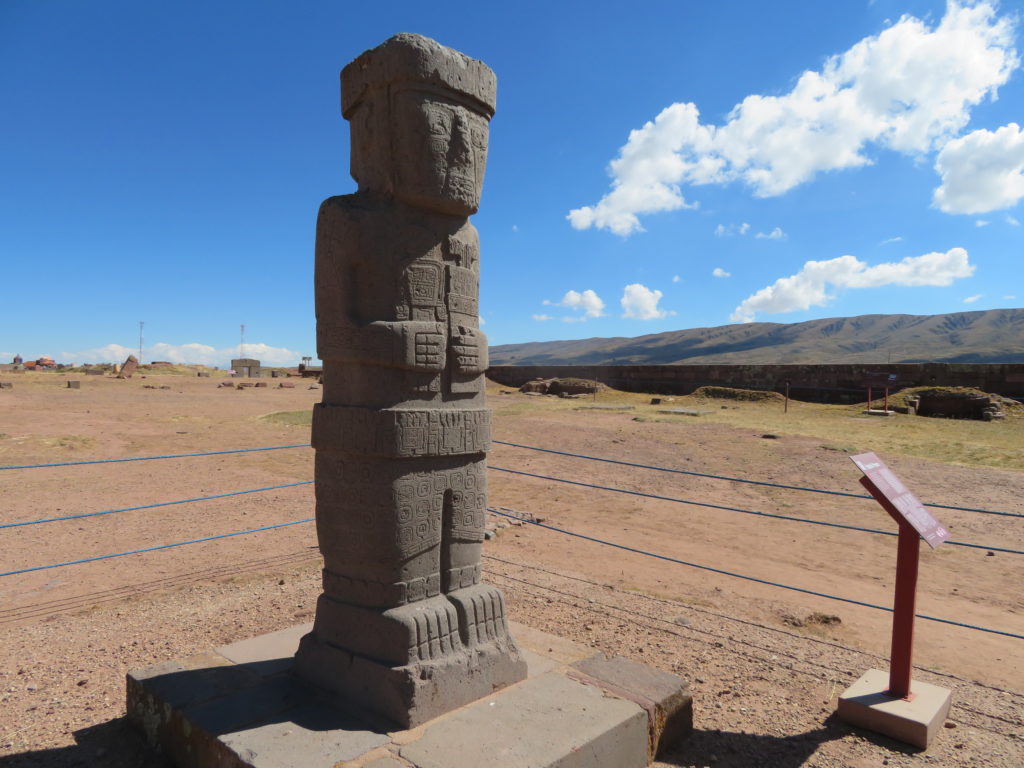
Visiting Tiwanaku pre-columbian archeological site the next day: The “Gate of the Sun”
Another famous statue of the religious complex
It’s easy to make new friends here 🙂
Huayna Potosi (6088 m) seen from the road back to El Alto
Descending to the city center with an aerial cable car (the cheapest and fastest method)
La Paz: Crowded traffic with lots of street vendors on both sides
Arriving in Uyuni (hostel)
Starting from Uyuni with a private driver to the south-western alpine desert, where my target is located. There are daily flights from the capital. Uyuni is a prosperous touristic center, all because of the nearby Salar de Uyuni, the biggest salt flat in the world (more than 10.000 square km’s, over 140 km’s in diameter)
San Cristobal silver mine
Villa Alota village
Climbing higher and higher. I start to feel dizzy
At over 4600 meters it is obvious: I’m not well acclimated…
Snowy peaks on the chilean border
Approaching the Eduardo Avaroa National Park. You need to buy an entrance fee here
Straight towards my target
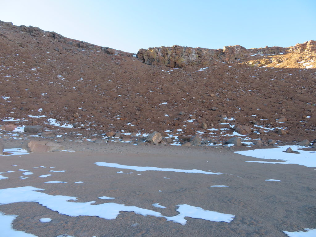
The final part became more wintry, but still manageable without any technical difficulties. We are approaching 4900 meters elevation
I start the journey by foot around 1:30 PM from near the fumaroles and hot muds of the Sol de Manana complex. Some tourists are present at the bigger geysers. The weather is quite windy and felt much colder than at the lower elevations
First time above 5000 meters. I’m in good shape but the backpack feels heavy at these altitudes. The breathing is difficult. From here I can see Aguita Brava volcano in front of me
Tired, around 5 PM I set my camp on the barren plateau. No tent, only a bivy sack and a good sleeping bag. My survival strategy is to shelter from the westerly winds behind a big boulder
Below -20 degrees on the ground beside me. The night is clear and surprisingly even windless. The Milky Way looks completely different from these heights. It is more similar to the nebulas seen on Discovery or National Geographic. After some hours of strong headache and nausea I start to feel better and decide to climb the mountain in the dark to reach the crater’s bottom before sunrise. I leave the unnecesary things here, securing the bivy sack with nearby rocks and at 4 AM I’m heading to the volcano
The main peak was farther than I thought. The sunrise found me struggling on the ridge. But the view is awesome!
Finally at 5500 meters on the top of Aguita Brava. No wind even here, I feel very lucky
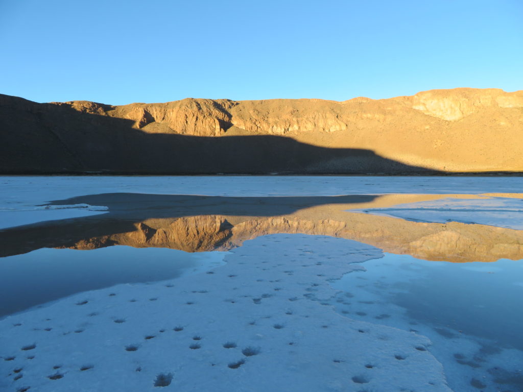
First view of the crater. The lowest part still in shade. What? A lake? I didn’t expected this. The place is completely dry on GoogleEarth
While descending in the caldera I suddenly feel how the cold is intensifying. It means the inversion layer is thick, filling the entire endorheic part of the basin. Okay, it’s no water nor ice at the bottom, only a dry lakebed. But a strange thin mist was present on the lowermost layer. Probably this tricked me. First I thought it is something related to the volcanic activity like the fumaroles at Sol de Manana
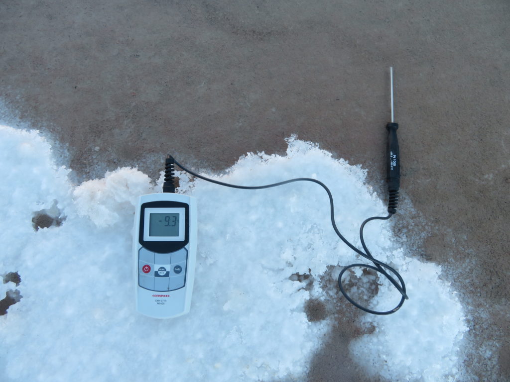
I do a quick near surface measurement with the electronic precision device. Wow! That’s really impressive for a tropical latitude!
The alcohol thermometer shows even lower values. It seems I’m not late. Here the night is not over. The mist must be caused by the strong inversion. I know the air is extremely dry on the Altiplano in the wintertime, but here on the bottom, close to the ground probably contains much more water vapour
In a couple of minutes the weather station started its activity. The snow mound is where I buried the logger to protect it from the extreme cold. The sensor can measure down to -40 degrees, but the logger itself is functional only to -30
It was difficult. But the project is on track
As the sun reached the lowest parts, after only a couple of minutes became considerable warmer in the crater
My self-designed talisman at the bottom of Aguita Brava caldera
Juriques volcano (5704 m) in the background
Putana (5890 m), the smoking volcano (sulphur dioxide) is another major peak on the chilean border
The plant living at the highest altitudes (around 5200 meters)
At noon became surprisingly warm. Still no wind, my face is burning. As the water in the thermos is lessening I compensate the fluid loss by eating small ammounts of snow. Dehydration is a serious danger at high altitudes
Around 2 PM, back to the camp. The other thermos waits for me here
Exhausted but very content. I go to sleep early today
Next morning. Doesn’t slept much, but the long rest was certainly helping
Approaching Sol de Manana geysers
Nobody is here now, I can enjoy the nature’s spectacle in solitude
Primordial landscape. The battle between cold and heat
After reaching the main road, I was waiting for the trucks which are coming from the Apacheta mine. Non of them appeared, but I had luck with a jeep coming from the geysers
At Polques hot springs. The driver will take some tourists to the border than he will pick me up here and we will reach Uyuni in the evening
Local bird hunting in the shallow water
Laguna Chalviri (around 4400 meters elevation)
Yeah, here the winter UV is stronger than at home the summer version. By the way: today I’m turning 40…
Uturunku, the highest peak in southern Bolivia. On the way back to Uyuni
Two days later I take a local bus (very cheap) to cross the famous Salar de Uyuni. Close to the shore is puddly, but after that is only dry salt pan as far as you can see
Short stop at Incahuasi island in the middle of the salar
The bus has elevated bottom, probably to can handle the puddles close to the shore
Almost 150 km’s of pure whiteness. We are heading to Llica settlement on the other side of the salar
From the village (background) I will go to a lesser known but very interesting geological structure: the Hoyada Ulo meteor crater
I had the crater’s coordinates on my GPS, but didn’t really know which way is the best. It ‘s around 7-8 km’s in straight line. Meanwhile the landscape became “western-like”
I reach the high plato around sunset. Feeling some presence of indian spirits I continue the hike until dark
Next day at dawn I’m on the rim of the crater. Surpisingly mild +1 degree Celsius here at head level. (I know. This picture looks like a movie screenshot from the 60′ 🙂
But I measure -14 degrees on the bottom. Nice inversion.
A smaller salar. Partially frozen now
That’s water there. Very salty, therefore still liquid at these temperatures
After the sun appears the season changes to spring. I decide to climb to the highest ledge
Definitely worth the effort! Salar de Coipasa, another huge salt flat can be seen in the background
A condor is patrolling above his empire
The weird “viscacha” is like a hybrid between a marmot, a squirrel and a rabbit
No way. I must turn back. Meanwhile became quite warm
When returning I found llamas on the bottom. Very peaceful animals, like bolivian people in general. No need for shepherd dogs, as the bigger predators are rare on the Altiplano. Pumas are said to live “everywhere”, but the reality is they are in small numbers for the huge territory. Meanwhile the temperature climbed to +16 degrees. Remember the -14 from the morning? That means a 30 degrees daily amplitude!
Before complete dark I reach Llica. It was a long day. I think the coca leaves helped me 😉
Rising more than 1600 meters above the flat landscape, Volcan Tunupa (5321 m) is the biggest landmark in the middle of the salt desert. On the car back to Uyuni
The bus is creating waves on the waters close to the shoreline
Two days later I start the second (and last) trip to Aguita Brava. As now the full tourist circuit is open the approache is much cheaper. I travel with two french who are heading to Chile. I think french are the most common tourists in Bolivia
Reaching Villa Mar settlement in the late afternoon. After sleeping in the village we continue the journey to the high plateau the next morning
This snow wasn’t there the other day. Certainly the wind is responsible for this change. We must turn back a little to take the smaller road
Before 8 AM I leave the car. It is windy and the -8 degrees feels much colder. My plan is to climb the mountain today and descend to the other side tomorrow
The wind intensifies, the sun has no warming effect in these circumstances. It’s ironic how similar the pictures can be while representing completely different realities
In the first part I felt markedly stronger than the other time but above 5100 meters the walking/ breathing became harder and harder. The last 100-200 meters was a complete struggle. I thought after 2 weeks at 3500-4000 meters I can handle these heights without any problems. But it was far from truth. The 1400-1500 meter ascent in 7 hours was too much
I left the unnecessary luggage on the rim of the crater. The westerly wind was very strong here, blowing straight in my face while I started the descend into the caldera
Oh, no… After this extreme struggle I found the weather station on the bottom fallen over. I underestimated the local weather conditions trusting the crater’s “sheltering effect”. But the gales were present even here. Even now is present! Luckily non of the instruments were damaged and I managed to collect everything. I also checked the logger’s daily statistics and found out the best day was the first when the temperature climbed from -26.6 degrees to +4 degrees Celsius
The steep climb on the friable volcanic debris back to the rim was somehow less strenuous than I was expecting after the former difficulties. My guess is that after the organism is over the highest part and starts descending again it recovers (partially). Therefore a new climb will be less hard as you have already visited the former height before. I understand the logic and also knew the theory, but I’m surprized because of the contrasts and because of the short time you need for these changes. After packing full my backpack again I started to descend the mountain on the otherside
No real altitude sickness from now on, but I was definitely exhausted when reaching this boulder where I set the same kind of camp (around 5000 meters elevation). Now the protection has real meaning as the westerly is still blowing. It was a very hard day. Time to sleep
Next morning I’m heading to the Dali Desert, where the main road is passing. The night was alternately windy, with some calm intervals between. It was nice full moon and in a certain time the bright disk was positioned exactly above my head. I mean vertically
The surreal Cerro Amarillo (5661 m)
The wind became even stronger while I reached the road, but the lower elevation and higher sun angle takes away from the cold. After a new bath at Polques (where I met 2 other hungarians) a jeep taked me back to Uyuni. The same reasonable price again
The main plaza in Uyuni. The small town is a tourist magnet. There is little to see in the settlement itself, everything is about the salar. The small center area is crowded with hostels, tourism offices and restaurants
And of course: souvenir shops
Tours and tours and tours… Sharp contrast between the small, modest brick buildings and the big, colored buses and modern jeeps
Many street dogs, but they are all harmless. In Bolivia the quadrupeds are surprisingly gentle
Pique macho, a traditional bolivian dish. Not really a delicacy, but good when hungry. Or just to tease the many scandinavian feminists 😉
In the same evening I’m back to La Paz. The plane took off 20 minutes…earlier. Never seen such a thing in my life. I was very surprised how easy is to travel in Bolivia. Maybe too easy?
Plaza Murillo, one of the main meeting places of the capital
Mercado a Las Brujas (Witches Market), another tourist hotspot of the center area. Beside the many colored clothes and wallets you can found here all kinds of weird things like various medicinal plants and even dried llama fetuses
The next day I visit the National Weather Service’s office and found out some important infos (see in part 3)
As tomorrow in the morning I will start my journey back to Europe I will use this day to see more of the city. Heading down to the lower elevations
There are many cable car lines, all colored differently
The richer part of the city
In the afternoon I climbed a precipitous hill situated in the outskirts. It was quite difficult because of the friable rocks, also uncomfortable, as many cactuses grow on the steep sides
I have no time for the highest peak, the relief is too fragmented from this side
The high Andes at sunrise from the plane. Bye lack of oxygen!
3 thoughts on “Aguita Brava volcano: Mars on Earth (2/3)”
Great adventure and very interesting! Beautifull pictures. It is quite a risky effort to find the earth’s extreme climates and to document them. Also happy 40th bday!
Thanks, Jan. Hopefully I can do more similar activities in the future. Still with many plans in my head, including breaking the minimum temperature record of my country.
“…including breaking the minimum temperature record of my country.”
Sounds exciting!