Interpretation of the logger’s graph (using LogTag Analyzer 3 software)

First night (14th January)
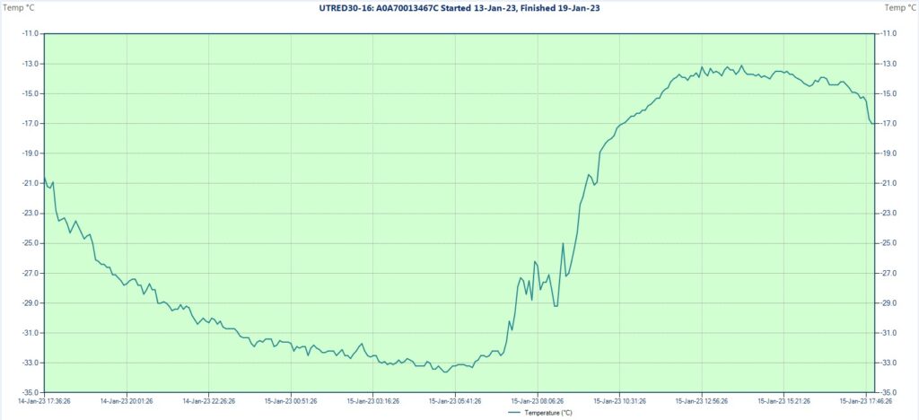
I installed the measuring equipment on the bottom of the closed basin in the second part of the night during clear and calm conditions. The logger set for 5 minutes intervals was started at 2:26 AM and the first reading showed -32.5 degrees Celsius. The second value is -33.2 C, which remains constant for the next 20 minutes, so its possible that the debut temperature actually was the same. I left the tripod around 2:40 AM and returned there in the early morning. During my walk from the tent situated aproximatively 2.5 km to the south I measured in the col between -26, -27 degrees with the handheld device, noticing also some wind there. The night remained entirely clear and on the bottom were the same calm conditions as at the time of the installation.

However, the temperature wasn’t lower in the dawn than before, the device showing -32.5 degrees at the first check. The recorded minimum was -34.1 degrees Celsius, which happened at 5:31 and 5:36 AM. A pretty constant night curve. But there are two more interesting aspects, one is the weak thermal inversion related to the context, which is around 6, maybe 7 degrees compared with the col, the other the complete lack of hoarfrost, which denote an extremely low humidity. I left the basin after sunrise. The entire day remained cloudless with only weak wind even on the ridges. The maximum, which I saw after returning in the next morning reached -16.3 degrees Celsius at 2:56 PM. That means a pretty big amplitude (17.8 degrees), which was expectable for a high altitude basin.
Second night (14-15th January)
The dark hours were completely starry again, but the wind intensified in the latter part of the night. Before the instability I measured down to -27 degrees inside my tent, expecting to see an even colder recorded minimum in the endorheic basin. It wasn’t the case, the lowest achieved temperature being only -33.6 degrees Celsius (at 5:21 and 5:26 AM), half degree warmer than before. As these two nights represents characteristic anticyclonic conditions I think that a generalization regarding the relatively weak thermal inversion of this place in snow-free context is very plausible.

While there before sunrise I observed the first cirrus clouds coming from the west. I left the basin soon and around noon also my camp. The day was generally fine but ocasionally windier, the sky partially covered by cirrus and cirrostratus clouds, with some thickening in the late afternoon period. I was spending my time around 10 km to the south of the research area staying in yurt with locals. The maximum of this day reached -13.1 C at 2:06 PM, which combined with the minimum of the dawn gives an amplitude of 20.5 degrees.
Third night (15-16th January)
From now on I will not visit the studied spot until the final day when I will collect the equipment, but will remain in its neighborhood (no more than 15 km away) most of the time. In the morning I measured -20.7 degrees with the handheld device at the yurt. The sky was mostly cloudy, overcast or variable with intensifying wind in the early afternoon when there were some very weak snow showers here and there, covering some parts with a new veil with a thickness of a few millimeters. In the latter part of the day the sky cleared up.

The diagram confirms the unstable weathern pattern, the curve being less regular and showing a smaller amplitude. The minimum reached -25.6 degrees Celsius at 9:25 AM, while the maximum -18.2 at 1:36 PM, the latter actually being colder than the late evening hours of the previous day. The 7.4 degree amplitude is the weakest one in the entire research period.
Fourth night (16-17th January)
While fair in the first part, the sky became overcast during the night. The curve reflects this as the minimum of -31.5 degrees Celsius was reached already in the late evening at 11:16 PM. In the morning I measured -20.8 degrees at the yurt, while observing a cloudy sky. The mostly overcast conditions persisted throughout the day in the whole area, including Ulaantolgoy where we made a trip with the car. Generally it was moderately windy.

The maximum reached -10.9 degrees Celsius at 1:56 PM, which is the highest temperature of the entire research. The daily amplitude of 20.6 degrees is also the biggest one, slightly exceeding the one from 15th. However, this can’t be considered a real endogen thermal span like the ones forming during stable weather conditions.
Fifth night (17-18th January)
This night was the windiest, more precisely the second part when I observed the yurt’s rooftop shaking a little at a certain time. In the morning the sky was clear, but because of the instability the temperature was even less cold than in the previous two cloudy days: -19.4 degrees. The minimum was reached again in the first part of the dark hours: -27.5 degrees Celsius at 11:21 PM when the conditions were more stable, while afterwards the temperature rised 10 full degrees during the second part of the night when the wind became dominant.

The maximum happened at 2:16 PM when the temperature climbed to -12.2 degrees, the second highest peak of the research. Today the sky was strikingly bright, even more transparent than on 14th, with only a few isolated clouds lingering above the higher peaks on the distance. It remained moderately windy throughout the day. The 15.3 degree amplitude can be considered average.
Sixth (last) night (18-19th January)
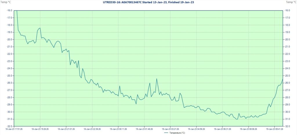
This was the coldest night by far at the yurt. The sky remained starry and there was nothing more than light wind. In the morning I measured -26.8 degrees. This time I observed also hoarfrost on the surface, thus the humidity was higher than before. I expected again to found a lower temperature in the closed basin (at least -33 to be precise), but surprisingly the minimum didn’t went below -31 degrees Celsius there, reinforcing my previous conclusion regarding the weak thermal inversion of this high elevation + snow-free combination.

The low temp was reached at 7:21 and 7:26 AM in the morning after a relatively regular night curve with some mild to moderate disturbance between 1 AM and 4 AM. Leaving the yurt, as we started our way back to Khovd, I went to collect the measuring equipment. The logger was stopped at 10:18 AM, the last reading showing -25.4 degrees Celsius. During this period it was calm and the sky was partially covered with cirrus and cirrostratus clouds.
The mean temperature of the 6 nights/ 5 days research period is -22.5 degrees Celsius, with the average minimum -30.6, respectively the maximum -14.1 degrees. The average daily amplitude is 16.3 degrees.
General conclusions
- The elevated basins situated on the lee side of the Mongolian Altai’s main ridge are characterized by very dry winters, receiving scant amounts of snowfall, often remaining without snow cover for the biggest part of the cold season. The stronger solar radiation and more active wind also helps to maintain the already desiccated state, sublimating the thin layer of white powder. This combined with the seasonally dominant anticyclonic conditions make these places some of the best contestants to produce the lowest temperatures in snow-free context.
- The thermal inversion formed at the bottom of these bare basins are not really strong, the surrounding ridges and slopes cooling down to almost the same degree during the night. The main cause in this respect probably is the absence of the snow cover and not the elevation itself, also maybe because the plateau as a whole could be partially inside the inversion layer.
- Compared with similar topographical contexts situated at lower elevations the daily maximums are higher (the inversion here brakes completely), while the minimums can be close to each other.
- The air is very dry on the high plateau, sometimes also in the night, restraining the formation of the hoarfrost even at extremely low temperatures.
- The wind in the wintertime is generally not strong.

Comparing my logger’s results with the minimums registered at the official local stations situated also in generally snowfree areas
During my staying I visited the weather stations of Möst, Mönkhkhairkhan and Khovd where I asked about the parameters observed in these colder winter days. On 14th Khovd (Khovd aimag/ 1406 m) and Ömnögobi (Uvs aimag/ 1590 m) both recorded -28.7 C, the latter -31.2 C the day before, while Nogoonnuur (Bayan Ölgiy aimag/ 1480 m) -26.2 C, respectively -30.8 C on 13th. Möst (Khovd aimag/ 2020 m) reached -30.1 C on 14th and was slightly warmer both on 13th and 15th, while Mönkhkhairkhan (Khovd aimag/ 2090 m) was colder on 13th with -30.3, while having only -28 on 14th.
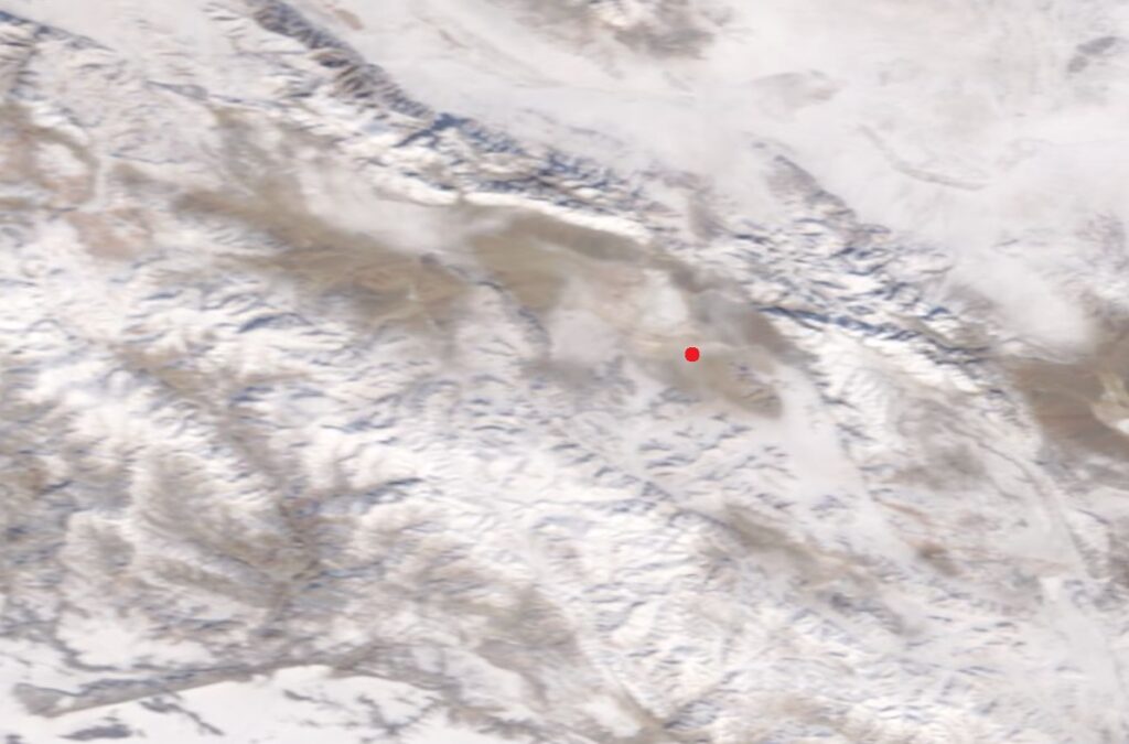
The coldest station which reported no snow cover at that time was Tsetsegnuur (Khovd aimag/ 1715 m) situated in a closed intermountain basin near the lake with the same name: -34.4 degrees Celsius on 14th January. This is even slightly colder than the value registered by my station. However, I checked the satellite image of the Tsetseg basin for that day (lower-right corner of the above image) and saw that actually there is a thin layer of snow in most parts. This doesn’t mean they gave incorrect data as the stations are obliged to report the snow depth they see at the rulers placed on the weather platform. The snow often can disappear sooner there, while in the surroundings still remains some.
At the weather center in Ulaanbaatar I asked if they have some statistics regarding the lowest temperature measured in snow-free conditions. They didn’t have, but together we searched for Tsetseg specifically and found a minimum of -36 degrees on 23th January 2012. At home I checked the satellite image also for this day and the result was similar: the basin wasn’t completely bare (see the picture below).

As a conclusion I would say that between the official weather stations of Mongolia indeed Tsetsegnuur has the biggest chances to reach the lowest temperatures. This because of the combination between the good topography (high+closed), respectively the rain shadow effect caused by the Mongol Altai’s main ridge which blocks the humid airmasses on the other side. The same as in the case of Jargalantyn Mukhar.
Final question: How cold can get in snow-free context and exactly where in the world are the best chances for this to happen? My opinion is that some areas of Mongolia and the northern part of the Tibetan Plateau could reach even slightly lower than -40 degrees in the best circumstances. As I am determined to research this little studied domain farther, the future certainly still has many other thrillful things to offer.
